
Understanding Satellite Image Classification
What is Satellite Image Classification?
Definition and Purpose
Satellite image classification is the process of sorting pixels into a finite number of individual classes, or categories of data, based on their data file values. It involves extracting information classes from a multiband raster image. This can then be used to create thematic maps.
Essentially, it's about making sense of the vast amounts of data captured by satellites orbiting Earth. The purpose is to categorize different features on the Earth's surface, such as water bodies, vegetation, urban areas, and bare land.
Importance in Remote Sensing
In remote sensing, image classification plays a vital role. Experts use remote sensing to obtain high-resolution satellite images.
This is crucial for monitoring changes over large areas. It allows for the observation of dynamic processes like deforestation, urban expansion, and changes in land use. Using remote sensing software, we can track changes in vegetation, land cover, and water bodies.
Key Techniques in Satellite Image Classification
Supervised Classification Methods
Overview of supervised classification
Supervised classification uses the spectral signatures obtained from training samples to classify an image. You identify examples of the known land cover types that you want to map.
The software then uses these training areas to identify all similar areas in the image. It requires prior knowledge of the area being studied.
Training samples and signature files
Training samples are areas selected by the user that represent each land cover class. The software uses these samples to create a signature file.
A signature file stores the spectral information of each class. These signatures guide the classification process.
Common algorithms (e.g., Maximum Likelihood, Support Vector Machine)
Several algorithms are used in supervised classification. Maximum Likelihood is a common method.
Support Vector Machine (SVM) is another powerful algorithm. SVM is one of the best classification algorithms in remote sensing.
Unsupervised Classification Techniques
Explanation of unsupervised classification
Unsupervised classification does not require prior knowledge. Instead, it groups pixels into clusters based on their spectral properties.
The user then assigns land cover classes to these clusters. It's a more automated approach.
Clustering methods (e.g., K-means, ISODATA)
K-means and ISODATA are popular clustering algorithms. K-means divides data into a predefined number of clusters.
ISODATA is an iterative process that refines the clusters. These methods help in identifying natural groupings in the data.
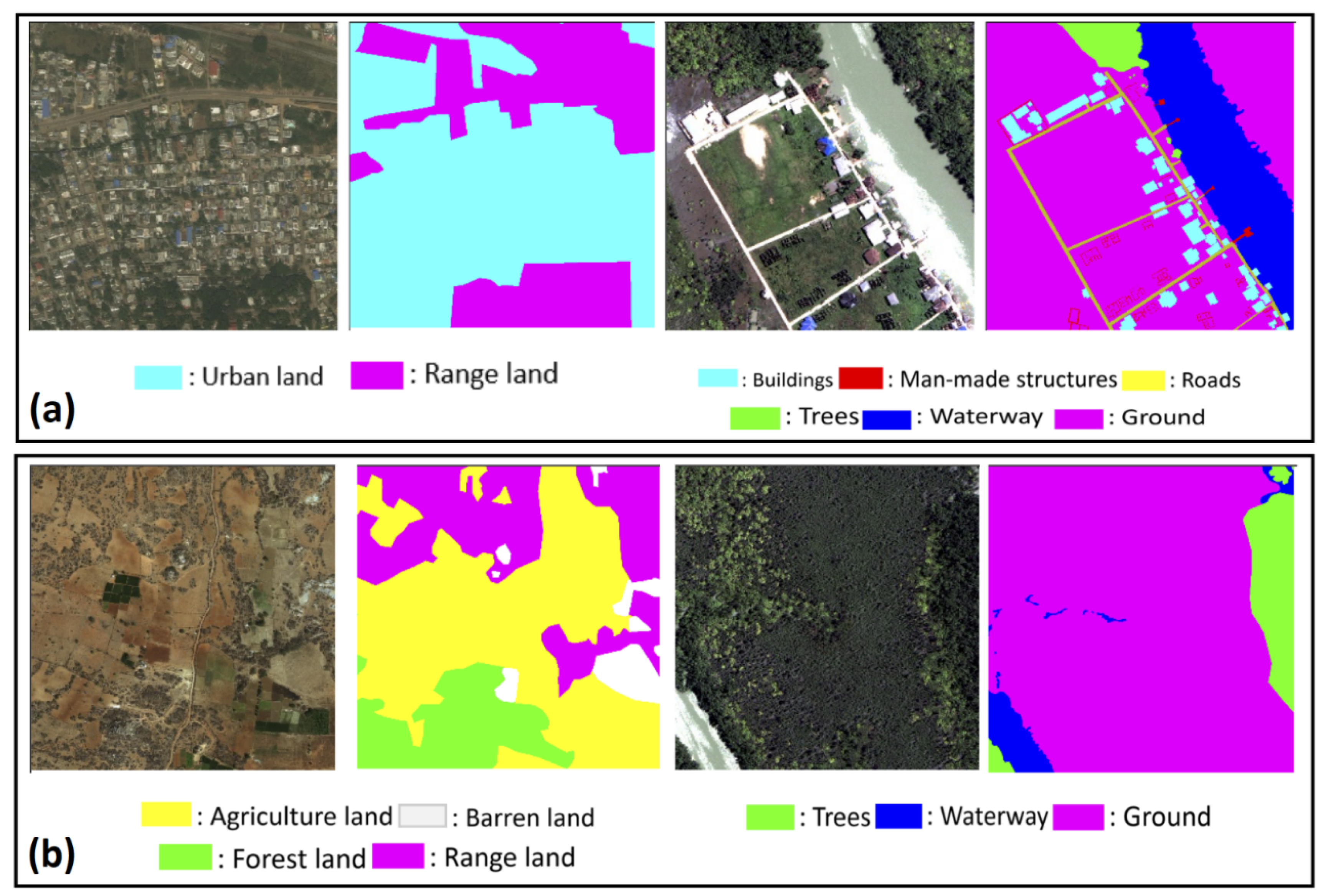
Object-Based Image Analysis (OBIA)
Definition and advantages of OBIA
Object-Based Image Analysis (OBIA) groups pixels into objects based on spatial and spectral characteristics. Unlike pixel-based methods, OBIA considers the shape, size, and texture of objects.
This approach is particularly useful for high-resolution imagery. It provides more accurate and meaningful results.
Comparison with pixel-based methods
Pixel-based methods classify each pixel individually. This can lead to a "salt and pepper" effect, especially in heterogeneous areas.
OBIA, on the other hand, creates more homogeneous and realistic objects. It reduces noise and improves classification accuracy. OBIA is superior to traditional pixel-based classification when you have a high spatial resolution image.
Applications of Satellite Image Classification
Environmental Monitoring
Role in tracking vegetation and land cover changes
Satellite image classification is crucial for environmental monitoring. It helps track changes in vegetation and land cover over time.
This information is vital for understanding ecological dynamics. It supports conservation efforts and sustainable resource management.
Use in biodiversity assessments and deforestation tracking
Biodiversity assessments benefit from classified satellite images. They provide insights into habitat distribution and fragmentation.
Deforestation can be monitored effectively using this technology. It allows for timely interventions to protect forests.
Agriculture and Precision Farming
Monitoring crop health and optimizing resources
In agriculture, satellite image classification helps monitor crop health. It enables farmers to identify stress factors early on.
This leads to optimized use of resources like water and fertilizers. For example, by using multispectral and hyperspectral images, farmers may identify infections and optimize irrigation techniques.
Applications in pest and irrigation management
Pest infestations can be detected using classified imagery. Irrigation management is also improved.
Farmers can make informed decisions, leading to higher yields and sustainable practices. Satellite data helps precision agriculture by offering information on crop health and yield forecasts.
Disaster Management and Response
Real-time damage assessment and relief operations
Satellite image classification plays a critical role in disaster management. It provides real-time data for damage assessment.
Relief operations can be planned more effectively. This ensures timely aid to affected areas.
Satellite imagery in post-disaster recovery planning
Post-disaster recovery also benefits from classified imagery. It helps in assessing the extent of damage.
This information is crucial for rebuilding infrastructure and restoring livelihoods. Satellite imagery helps with damage assessment and recovery planning in post-disaster settings.

Urban Planning and Infrastructure Development
Mapping land use and urban growth
Urban planners use satellite image classification to map land use. It helps in understanding urban growth patterns.
This information is essential for sustainable urban development. City planners can make educated decisions about zoning, transit networks and infrastructure development.
Assessing infrastructure needs and environmental impacts
Infrastructure needs can be assessed using classified imagery. It also helps in evaluating the environmental impacts of development projects.
This ensures that urban expansion is balanced with environmental conservation. Satellite imaging is a vital tool in urban planning that helps map and track changes in land use.
Benefits of Satellite Imagery in Environmental Monitoring
Comprehensive Coverage and Real-time Data
Importance of satellite data for large-scale environmental analysis
Satellite data provides comprehensive coverage of large areas. This is crucial for environmental analysis.
Real-time data allows for continuous monitoring. It helps in detecting changes as they occur.
Cost-effectiveness and efficiency in data collection
Collecting data through traditional methods can be costly and time-consuming. Satellite imagery offers a cost-effective alternative.
It is an efficient way to gather large amounts of data quickly. For example, high-resolution satellite photography is used in forestry management to track the health of forests over time.
Enhanced Decision-Making Capabilities
Integration of satellite data with GIS for informed policy-making
Integrating satellite data with Geographic Information Systems (GIS) enhances decision-making. Policymakers can make informed decisions based on accurate and up-to-date information.
Geospatial analysis using GIS technology makes it possible to locate impacted locations and gauge the severity of the situation. The integration of satellite imagery and GIS technologies facilitates the production of precise and dependable maps.
Case studies showcasing successful applications
Many case studies demonstrate the successful use of satellite imagery. For instance, monitoring deforestation in the Amazon rainforest.
Another example is tracking urban growth in rapidly developing cities. These applications highlight the power of satellite data in environmental management.
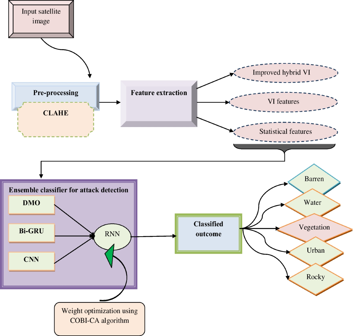
Machine Learning in Satellite Image Analysis
Overview of Machine Learning Techniques
Introduction to machine learning applications in satellite data
Machine learning is revolutionizing satellite image analysis. Techniques like neural networks and deep learning are being used to improve classification accuracy.
These methods can handle complex patterns and large datasets. There will soon be more companies providing affordable access to satellite images.
Examples of successful machine learning models for classification
Several successful models have been developed. Convolutional Neural Networks (CNNs) are widely used for image classification.
Recurrent Neural Networks (RNNs) are effective for time-series analysis. These models are enhancing the capabilities of satellite image analysis.
Accessibility and Future Trends
Developing user-friendly tools to democratize satellite data access
Efforts are being made to make satellite data more accessible. User-friendly tools and platforms are being developed.
This will enable more people to utilize satellite imagery for various applications. It's like Ford's Model T, but with machine learning and satellites.
The potential of AI and machine learning to enhance satellite imagery insights
Artificial Intelligence (AI) and machine learning hold great promise. They can provide deeper insights from satellite data.
This will lead to more accurate and efficient environmental monitoring and management. AI algorithms can process large volumes of data, automating the identification of objects or surface changes.
Conclusion
Satellite image classification is a powerful tool for understanding our planet. It has wide-ranging applications in environmental monitoring, agriculture, disaster management, and urban planning.
Techniques like supervised and unsupervised classification, along with OBIA, provide valuable insights from satellite data. The integration of machine learning is further enhancing the accuracy and efficiency of these methods. The future of satellite imagery looks promising, with ongoing advancements making this technology more accessible and powerful.
Key Takeaways:
- Satellite image classification categorizes pixels into specific classes, aiding in thematic mapping and environmental monitoring.
- Supervised, unsupervised, and object-based methods offer diverse approaches to analyzing satellite data.
- Applications span environmental monitoring, agriculture, disaster management, and urban planning, showcasing broad utility.
- Machine learning and AI are set to revolutionize satellite image analysis, promising enhanced accuracy and accessibility.
- Future trends indicate a move towards more user-friendly tools, democratizing access to satellite data insights.